Riparian Areas
Objectives
Preserve riparian areas to maintain:
- Habitat preservation and connectivity;
- Short and long term water quality; and,
- Stormwater management, flood, and erosion control
Guidelines and Best Practices
Avoidance and Minimization
- Strive to preserve riparian habitat for all intermittent and perennial streams as shown on the USGS 7.5 minute quadrangles, and when possible, maintain or preserve the natural area within the FEMA 100-year floodplain.
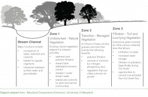
- Best practices show that a minimum total buffer width of 100 feet is necessary to achieve the objectives outlined above. Healthy stream bank buffers provide for future stream movement, and support different ecosystem services or environmental benefits through characteristics that can be described in three types of zones:
Zone 1: Protect and preserve existing vegetation and habitat immediately adjacent to the stream.
Zone 2: Retain a transition area of grass and lower vegetation beyond the protected vegetation or tree line adjacent to the stream.
Zone 3: Maintain turf or other pervious materials to allow for filtration of sediment and pollutants from runoff beyond the protected vegetated area.
- Maintain stream bank buffers in a natural or enhanced state, and keep all structures and impervious paving at least 100 feet from the stream bank. The buffer width should accommodate future stream movement, mitigate against erosion and flooding issues, and preserve the greatest extent of existing habitat possible. If less than a 100 feet buffer is proposed, the development should demonstrate that the objectives of habitat preservation and connectivity, stormwater management and flood control, erosion control, and filtration and water quality are being achieved through alternative means.
- In Urban LUTAs, the width of the buffer may vary based on the quality and condition of vegetation, animal and plant species, watershed level issues and adjacent land use. The buffer may extend into private property, provided easements or agreements are stipulated to ensure that obstructions such as fences do not disrupt water flow or natural systems that are being preserved within the buffer area.
Restoration
- Streams that have been impacted due to previous development, agricultural activities, or upstream/downstream activities may have absent or sparse vegetation that does not provide desired benefits and ecosystem services. A developer may supplement existing vegetation by integrating appropriate new species, or plant new vegetation consistent with the zones depicted in the graphic above to restore natural systems and habitat typical of healthy functioning streams and lakes.
Simulation
- A developer may use green infrastructure or low impact development techniques to mimic natural systems in areas where streams and riparian areas have been channelized or developed, primarily in the Downtown, UHI, and UMI LUTAs. Low impact development techniques include but are not limited to:
- Treating or filtering of stormwater contaminants on site.
- Creating opportunities to discharge run-off as sheet-flow after passing through grassy or vegetated open space areas, rather than discharging run-off through concentrated outfalls.
- Creating attractive open space amenities that double as stormwater detention, retention, and / or filtering systems.
- Utilizing rooftop collection systems and green roofs to capture first-flush run-off.
- Utilizing pervious pavement or pavers in appropriate locations (i.e. sidewalks, parking spaces, trails, patios, etc.).
- Utilizing at-grade or raised planters, vegetated landscape strips adjacent to roads and parking areas, and alternative curbing designs that allow stormwater to easily move from impervious areas to pervious areas.
