Land Use Plan
The Land Use Plan creates a vision for development throughout the city and establishes principles and policies applicable to all development. Its formulation was guided by varying types of public input and technical analysis regarding housing, transportation, environment, and the efficiency of providing public services. The Land Use Plan is made up of five primary sections:
Land Use Typology
Seven “base” Land Use Typology Areas (LUTAs) and seven “layer” LUTAs make up the planokc Land Use Plan LUTA map. Each LUTA focuses on the appropriate intensity of development for each part of the city and identifies areas designated for the provision of urban services (water, sewer, etc.), concentrations of commercial and employment uses, and preservation of rural and natural areas. Each LUTA has a set of development and density policies to guide compatible development.
Land Use Compatibility
A central feature of the Land Use Plan is to guide how various land uses can be integrated while still being compatible with each other, as opposed to the conventional method of geographically separating uses into separate zones in an attempt to avoid conflict between uses. The Compatibility Matrix identifies when there are likely to be conflicts between uses of different operation, scale, and traffic generation, and provides measures to address or mitigate any potential problems so that each LUTA can achieve a successful mixture of land uses.
Service Efficiency & Availability
The ability to provide efficient and cost-effective services is a central theme to the Land Use Plan. A detailed analysis of service efficiency as it relates to water, sanitary sewer, streets, solid waste, police, and fire services was conducted in order to identify locations within the city that can accommodate urbanized development. As the city grows, the ability of future development to be served efficiently through long-term maintenance of utilities—not just the up-front investment—will be a primary consideration for amendments to the Land Use Plan.
Environmentally Sensitive Areas
70 percent of planokc survey respondents expressed support for protecting natural areas, including providing better regulations and incentives to protect environmental and natural resources. The Environmentally Sensitive Areas (ESA) section of planokc identifies policies related to three specific types of natural areas: 1) upland forests; 2) riparian areas; and 3) aquifer vulnerability zones. These areas have special environmental attributes worthy of retention or special care, as they are critical for the maintenance of water quality, productive habitat, and stable soils.
Street Typology
The Street Typology connects with Land Use Typology to form the framework for the built environment of Oklahoma City. The relationship between land use and streets is crucial to how people move and access destinations such as home, workplace, and everywhere in-between. The Land Use Plan identifies key features of each Street Typology as it relates to different LUTAs, and guides how investment in streets throughout the city can best accommodate existing and future development.
PRINCIPLES OF THE LAND USE PLAN
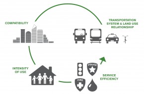
The concept of the Land Use Typology is to encourage a mixture of uses that work in harmony with each other within a particular area. It focuses on the relationship between land use and the nearby transportation network, considering the appropriate scale of existing and future development. The land use plan follows four key principles:
Compatibility
A key objective of land use planning is to create a land use pattern that prevents conflict between adjacent uses. We recognize that all land uses are not inherently compatible with others, but steps can be taken to ensure or improve compatibility between them. Successful integration of different land uses connects people to services and improves walkability and access to jobs, recreation, and other needs and amenities.
Intensity of Use
A central component of land use compatibility is the intensity of each use and how different uses relate to each other, whether it be building scale, the amount of traffic generated, or operational impacts. The LUTAs in the Land Use Plan are distinguished from each other based on intensity of land uses.
Transportation System & Land Use Relationship
Land use must be planned with transportation and the adjacent street network in mind, and vice versa. planokc‘s Land Use Plan is intricately connected with the Street Typology that guides how land use functions on certain streets, and how the City should invest in street infrastructure in the future.
Service Efficiency
The delivery of high quality, cost effective services is a high priority for the City and its citizens. Our analysis shows that some land use patterns are more costly to serve than others. The Land Use Plan, therefore, reflects a land use pattern that is intended to maximize the City’s ability to provide high quality, cost effective services such as water, sewer, and public safety to its residents and businesses.
