Initiatives
Each initiative below summarizes and explains related policies the City and its partners will pursue in order to accomplish goals related to transportation. Click on the initiatives below to view full explanations and related policies.
We will ensure that street improvements and expansions to the network serve the development vision of planokc. The Land Use Plan, the foundation of planokc, is based on efficient use of land resources, and incremental, market-based extensions of urban development. Road construction projects in undeveloped areas can have the opposite effect by encouraging decentralized development. Both city and regional road plans should reinforce the vision of efficiency by focusing on enhancing the existing network, addressing areas of congestion and poor operation, increasing network connectivity and route choice, and using new street extensions to guide development in desirable directions.
We will implement the street typology concept. The street typologies combine the function and context of streets to produce design standards. Our subdivision ordinances and design practices should be amended to be consistent with these standards. Different land uses and intensities of development also require streets with the ability to handle the traffic they generate. Therefore, new development should be located on streets of appropriate type and capacity, or include measures necessary to supply the required capacity.
Click to expand policy information.
Coordinate the design, development, expansion, and/or investment in transportation projects with the Land Use Typology map.
Require traffic impact analyses with all comprehensive plan amendments requests to change to a higher intensity LUTA.
Require the construction of new streets, streetscapes, and street widening projects to implement the design components of the assigned street typologies established in this plan.
Share parking among contiguous developments.
Revise Subdivision Regulations and development standards to reflect the street typology standards.
Identify and prioritize freight infrastructure projects that are needed to maintain mobility and enhance the city’s (and region’s) economic competitiveness.
Undertake targeted parking studies to determine existing parking capacity and develop appropriate parking standards based on land use, location, and demand.
Require sidewalks on both sides of all streets in urban LUTAs and in the Rural Residential LUTA for subdivisions with densities greater than 1 unit per acre.
Maintain historical lot and block sizes where possible and appropriate.
Assess the need for additional funds for citywide road maintenance beyond past average annual expenditures. If additional funds are needed for street maintenance, explore the feasibility of:
- Implementing a transportation utility fee; or
- Increasing the proportion of G.O. Bond money spent on street maintenance over past levels.
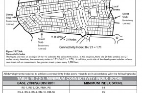
We will provide good street connections within and between neighborhoods to provide a choice of routes and separate local traffic from major arterials. Good street connectivity has many benefits. By providing alternative routes for short distance trips, it indirectly increases the capacity of arterial streets. It also provides better quiet street opportunities for pedestrians and bicyclists, and improves the efficiency of delivering emergency access and city services.
Click to expand policy information.
Maintain the traditional grid street pattern where it currently exists, reconnect it where possible, and keep alleys open and functioning. When improving older streets in neighborhoods, maintain original street widths and curb radii.
Improve the functionality and efficiency of the street network by:
- Providing direct connections from residential developments to nearby places and to each other.
- Providing street and sidewalk stubs to adjacent vacant land in anticipation of future development.
- Connecting new development to existing street and sidewalk stubs, and to existing trail, open space, and bicycle networks.
- Reducing block sizes and use of dead-end streets.
- Maintaining the existing street grid to preserve connectivity and mobility options.
Revise subdivision regulations to include connectivity standards and guidelines that require greater street connectivity, and provide allowances for pedestrian and bicycle connections when street connectivity cannot be made.
Change subdivision regulations to determine the number of entries into a residential development based on number of lots in order to improve connectivity of the roadway network and emergency response.
Maintain existing alleys or construct new alleys where feasible to provide trash collection service and parking behind primary buildings and minimize curb cuts along the primary street frontage.
Target specific areas of the city for enhanced safety and proactive enforcement. Selection of target areas will be informed by the Intelligence Led Policing program, with coordinated involvement from Police, Code Enforcement, Public Works Department, Planning, and community-based organizations.
Evaluate development proposals to assess design components that contribute to or detract from safety and analyze emergency response capacity and capability.
We will establish a systematic neighborhood street program, focused on rehabilitation, traffic calming, and safety and functional improvements. Citizens place a high priority on the condition and repair of the existing street system. The streets that affect residents most – local and connector streets – are rarely addressed by normal transportation programs. A systematic neighborhood street program will both provide regular funding for street repair and rehabilitation and completion of special street projects such as traffic calming.
Click to expand policy information.
Establish a process for existing neighborhoods to request traffic calming, including how to evaluate the request, select the appropriate type of calming treatment, and fund recommendations.
Improve parking provisions in neighborhoods that are near vibrant commercial corridors/areas by improving parking and corridor design, non-vehicular networks, transit, and signage.
Incorporate preventive health care and wellness education into public schools, recreation centers, senior centers, and technical/trade schools.
Evaluate development proposals to assess design components that contribute to or detract from safety and analyze emergency response capacity and capability.
We will incorporate all appropriate forms of transportation into major street and land use corridors. Major corridors provide access to important community destinations, including shopping centers, civic institutions, and employment centers. Multi-modal corridors do not require every form of transportation on every major street. Rather, the corridor taken broadly provides access for all modes of transportation to destinations along the way. For example, service roads, local streets, trails, or other paths parallel to arterials can accommodate local transit, pedestrians, and bicyclists comfortably. The concept of multi-modal corridors also requires that projects that change or expand the motor vehicle capacity of major streets and roads accommodate transit and active modes in the final design and during the construction process.
Click to expand policy information.
Set level of service goals and adopt standards to improve the performance of pedestrian, bicycle, and transit facilities. Emphasize pedestrian, bicycle and transit infrastructure in street widening designs.
Require the construction of new streets, streetscapes, and street widening projects to implement the design components of the assigned street typologies established in this plan.
When approving projects that improve the level of service for vehicular traffic, ensure they do not negatively impact the walkability or bikeability of the area.
Locate, design and upgrade City facilities and infrastructure in a manner that supports neighborhood revitalization and redevelopment.
We will maximize the safety and efficiency of arterials by developing and implementing new standards and strategic access management projects. New design standards and practices should reduce the number of driveway cuts on streets, encourage shared access points, develop properly designed service roads where appropriate, and align curb cuts across streets wherever possible. These changes are usually good for business because they increase the efficiency of parking, reduce crashes and conflict points, and reduce stress on customers and motorists.
Click to expand policy information.
Prioritize opportunities to restore and reconnect the street grid.
Establish access management requirements that limit driveways on arterials and collectors and increase connections between uses to improve safety and traffic efficiency.
Limit driveways on arterials and collectors and increase connections between uses to improve safety and traffic efficiency.
Share parking among contiguous developments.
Ensure proper access to and between subdivisions in order to offer a choice in routes for residents, multiple access points for emergency responders, and to reduce vehicle congestion at arterial intersections. Contiguous developments should share access whenever feasible.
Regional-, community-, and neighborhood-scale retail developments should provide an internal vehicle and pedestrian circulation system between new and existing centers and individual stores that draws on the following principles:
- Concentrate access for new retail development at shared primary entrance points. Primary entrance points should be aligned with access points immediately across intersecting roads. Limit curb cuts on primary highways and arterials.
- Provide pedestrian circulation, including sidewalks and median breaks along interior and exterior fronting roads and within parking lots.
- Encourage coordinated development of retail centers in order to facilitate internal pedestrian and vehicle circulation and optimal center performance.
Encourage unified planning for all adjoining land owned or controlled by a project’s developer to ensure proper circulation and land use relationships.
We will work to establish a regional authority for financing and operating transit in the Oklahoma City metropolitan area. Providing a quality public transportation service requires a reliable funding source. The need for and benefits of public transportation do not stop at the borders of Oklahoma City. Effective transit benefits the region in several ways, including providing direct services in and to surrounding cities and opening street and highway capacity for suburban commuters who do not use transit. A metropolitan authority can coordinate current regional services and expand into areas like commuter rail. Most importantly, it can provide a dedicated and stable source of funding – necessary for fully realizing transit initiatives recommended by the Fixed Guideway and Transit Analysis studies.
Click to expand policy information.
Support the creation of a regional transit authority and pursue the establishment of a dedicated funding source, such as sales tax or property tax to achieve long term transit service goals.
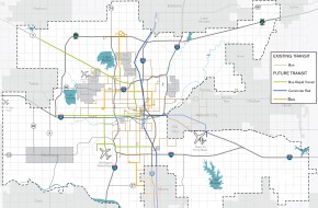
We will implement the general recommendations of the Transportation Service Analysis (TSA) and the Fixed Guideway Study (FGS). These two studies together define a transit future for Oklahoma City. The Service Analysis addresses enhancements of the existing bus system while the FGS provides a long-term direction that introduces new transit technologies. We have begun implementing elements of both studies. The restructured EMBARK system has made the substantial short-term route adjustments and re-imaging recommended by the TSA. The MAPS 3 program, approved by the voters, includes capital funding for a modern streetcar serving the Downtown area, a major recommendation of the FGS. Both projects will change the image and visibility of transit in the city.
The TSA established basic principles to guide short-term adjustments and longer-term system design. These guiding principles include simplicity of service, directness of routes, minimized transfer waits, operation along arterials, route symmetry in both directions, and service to rider destinations. Key long-term recommendations include weekend service expanded evening hours, and more frequent service on routes with high ridership potential. These service expansions are vital to expanding the relevance of transit to more people. The analysis also recommends new routes with available funds, including a direct service to the airport. New service should also serve destinations of special interest to both residents and visitors, using routes that will appeal to specific markets.
The FGS proposes a future system utilizing four technologies:
- Enhanced bus on the basic system, using conventional buses with more frequent service, longer operating hours, rider amenities such as shelters and schedule information at stops, less frequent stops, and faster operating speeds.
- Bus rapid transit (BRT) on four corridors: Reno Avenue, Northwest Expressway, 59th Street, and Meridian Avenue.
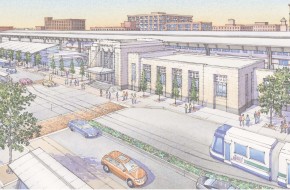
- Modern streetcar, to be implemented on a starter basis through MAPS 3 as noted earlier.
- Commuter rail on two corridors: the primary north-south route from Edmond to Norman via Downtown Oklahoma City and Downtown to Midwest City/Tinker Air Force Base.
Scheduling and funding for this 2008 study must be re-evaluated, but the basic long-term system concept remains sound.
Click to expand policy information.
Increase frequency and time of transit operations to ensure adequate, convenient and safe service for visitors, employees, and residents.
Focus transit improvements in high density areas with high ridership potential and along express routes that move people to activity nodes and downtown.
Implement policies and strategies recommended in the 2013 COTPA Transit Service Analysis.
Develop an urban rail and/or bus rapid transit system to connect downtown with strategic corridors and nodes.
We will develop facilities that encourage people to use other means of transportation to travel to transit stops and stations. The traditional service area around a transit route is a 1/4 mile walking distance. We should maintain clear and continuous pedestrian routes within that service area to transit stops or stations. Safe, comfortable, and attractive shelters and waiting areas should be located at strategic points along routes. Providing features that encourage people to bike or drive to stops and stations can extend these service areas and increase the number of potential riders. These features can include:
- Connections from trails to transit stops.
- Bike parking, lockers, and potentially rental stations at major transit stops and hubs.
- Park and ride facilities such as lots and structures, integrated into transit-oriented developments or at appropriate commuter sites.
Click to expand policy information.
Develop design standards for bus stops and transit stations that consider location, make connections to sidewalks and bicycle routes/trails, and provide safe, comfortable, and attractive waiting areas for riders.
Locate, design and upgrade City facilities and infrastructure in a manner that supports neighborhood revitalization and redevelopment.
We will incorporate transit access into street design standards and projects on appropriate corridors. As streets that carry transit routes are improved or modified, their design should include features that specifically encourage amenities, pedestrian access, and smoother operations. These features may include enhanced pedestrian access and street crossings at transit stops; signal cycles that give pedestrians time to cross streets; space for shelters; signal controls; and reserved lanes or “JUMP” lanes for bus rapid transit. In addition, street typology standards that include transit-friendly features should be implemented.
We will implement standards that provide good transit access and user connections to major projects on transit routes. The length and nature of the path between a transit stop and the entrance to a major destination determines whether a project really has adequate transit service. For example, a stop should not require people to find their way across a large parking lot to enter the development. New design standards for large projects with transit potential should provide safe and comfortable links from the transit stop, or provide routes into the project for transit use.
Click to expand policy information.
Revise development standards to require sidewalks and transit stops along existing and planned transit routes.
Develop design standards for bus stops and transit stations that consider location, make connections to sidewalks and bicycle routes/trails, and provide safe, comfortable, and attractive waiting areas for riders.
Ensure that new publicly financed developments – those which directly use or receive public dollars – with more than 100 units or with densities greater than 10 units/acre are located where they have easy access to frequent transit service.
We will implement appropriate transit service to Will Rogers World Airport. Airport transit services address two markets: airport employees and airline passengers. Many cities, including Oklahoma City, attempt to serve their airports by extending a local line, a technique which serves neither market effectively. The Transit Service Analysis recommends a direct bus service to the airport in its long-term, unconstrained resources scenario. The proposed route would serve the transit hub, Convention Center , and hotels, with typical weekday headways of 30 minutes.
Click to expand policy information.
We will design and implement a bicycle route system based on getting people to priority destinations. The current Bicycle Transportation Plan provides a two-phased network of potential bike routes. This network is based on evaluating various streets for bicycle suitability, and provides a solid foundation for implementation. The system should now be refined by considering destinations and designing routes that assemble on-street segments and trails into an entire network that serves multiple destinations.
We will incorporate appropriate support features such as bike parking and wayfinding signage into the system. On and off-street facilities function best with relatively inexpensive support facilities like parking and information graphics. Zoning ordinances and cost-sharing programs can both require, and encourage through incentives, bike parking for appropriate land uses, like major commercial, multi-family, and mixed use development. Desirable city actions include installing bike parking in public parking structures and business districts and encouraging bike “corrals” in which one parking space is dedicated to bike parking in neighborhood business districts.
Click to expand policy information.
Identify areas that could be used to establish a greenbelt network throughout the City that connect major employment centers, commercial sites, parks, and key locations within major residential neighborhoods. Use the greenbelt as the backbone for a bicycle trails network which all other bicycle trails feed into.
Create and implement a citywide bicycle and pedestrian master plan that addresses riders of all levels.
Require the placement of secure, properly positioned bicycle parking within multi-family and commercial development, and in all public parking garages.
We will establish and execute annual goals for completion of new bicycle infrastructure. Annual installation commitments ensure that new facilities are installed in a systematic way. These goals may be established for specific destination-based routes or for miles of such new facilities as shared use lanes or bike lanes. The annual performance goals also include incorporating bicycle facilities into resurfacing or construction projects of streets on the bicycle network.
Click to expand policy information.
Prioritize construction of pedestrian and bicycle facilities that improve connectivity and eliminate gaps in the transportation network.
Increase the miles of bike lanes by:
- Including bicycle lanes in future road widening, reconstruction, and resurfacing projects; and
- Adding bicycle lanes to streets that have sufficient capacity.
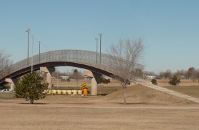
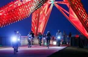
We will identify major obstacles to completion of important system connections and implement projects that bridge these barriers. Most interstate crossings are arterial streets, often with interchanges, creating conditions that many cyclists find hazardous. The city has previously developed projects to address these barriers such as the SkyDance Bridge over I-40 and the Woodson Park Bridge over I-44. Other barriers persist, such as the lack of safe crossings over I-44 between May Avenue and I-235, a high intensity area with many important destinations. Options for these projects include dedicated pathway bridges or retrofit of existing interchanges and arterial crossings for better pedestrian and bicycle accommodation.
Click to expand policy information.
Prioritize construction of pedestrian and bicycle facilities that improve connectivity and eliminate gaps in the transportation network.
We will work as a community to create a supportive environment based on the principles of engineering, education, enforcement, encouragement, and evaluation. The “5 E’s” which the League of American Bicyclists views as the measures of a bicycle friendly community recognize that engineering (bicycle infrastructure) alone does not create a successful bicycle culture. The other components include:
- Education, making cyclists and motorists aware of the rules and practices of safety and etiquette and their mutual rights and responsibilities as road users.
- Enforcement, helping to ensure safety by enforcing rules that pertain to all users.
- Encouragement, executing events and programs that promote bicycling and its many benefits.
- Evaluation, establishing benchmarks and measurements to gauge the effectiveness of bicycling initiatives.
Click to expand policy information.
Create and implement a citywide bicycle and pedestrian master plan that addresses riders of all levels.
Incorporate preventive health care and wellness education into public schools, recreation centers, senior centers, and technical/trade schools.
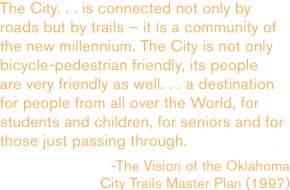
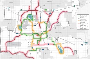
We will update the Trails Master Plan to be consistent with planokc policies, funding availability, and progress made since 1997. This visionary master plan, completed in 1997, called for completion of 208 miles of trails by 2020. We have made significant progress since then, and MAPS 3 will complete major parts of the proposed system by that date. We now should update this document in view of these accomplishments, new thinking about coordinating off- and on-street systems, increased community support for trails and active transportation, and resource availability.
The updated plan should include:
- Design of a new trail network coordinated with multi-modal streets, on-street bicycle/pedestrian routes, and potential greenbelts and green infrastructure.
- Updated trail design standards, using new documents such as the 2012 edition of the AASHTO Guide to the Design of Bicycle Facilities and other contemporary standards.
- Consistent identification and wayfinding graphics, unifying the trail system while allowing identification of individual trails.
- Public safety standards and measures, including design, view corridors, lighting, and communications.
Click to expand policy information.
Update, implement, and maintain the currency of the 1997 Oklahoma City Trails Master Plan.
Create a standards for trails based on industry standards, “Crime Prevention Through Environmental Design” principles, expected use, and surrounding land uses.
Create a standardized sign program for trails which unifies the trails and allows for each trail identity to be unique.
Identify areas that could be used to establish a greenbelt network throughout the City that connect major employment centers, commercial sites, parks, and key locations within major residential neighborhoods. Use the greenbelt as the backbone for a bicycle trails network which all other bicycle trails feed into.
Market the trails system as a transportation and recreation system to residents and visitors.
Acquire easements in new and existing developments to develop and connect trails.
Establish connections between parks, residential areas, and other points of interest by constructing additional bike routes, trails and pedestrian paths to meet the growing demands for recreation and alternative transportation routes.
We will develop a reliable and innovative funding program for the development and maintenance of trails. MAPS 3 will invest almost $40 million into trail construction between 2014 and 2020, completing three very difficult but critical trail links. This critical funding will create three excellent facilities and vastly increase the utility of existing trails. A more regular funding source needs to be established for building neighborhood connections, additional linkages between existing trails, greenways, and extensions of the core trail system. The traditional method of trail funding, the federal Transportation Alternatives program, faces challenges with every reauthorization of transportation bills and must compete for declining funds with a wider variety of projects. In addition, good trail maintenance is important, and total costs will increase as the system expands. Because trails are both transportation and recreation facilities (and sometime transportation to recreation), funding from the capital and operating budgets of both the Parks and Public Works Departments is both necessary and appropriate. But these funds are stretched thinly, and other sources should be explored. Private developments should build trails within their boundaries identified by the Trails Master Plan and connecting paths to nearby regional trails. Costs may be shared based on the level of local versus general benefit. We must explore these and other techniques to ensure that our trail system continues to both grow and be properly maintained.
Click to expand policy information.
Modify Subdivision Regulations to require new development adjacent to public trails to provide sufficient connections to the trails.
Update, implement, and maintain the currency of the 1997 Oklahoma City Trails Master Plan.
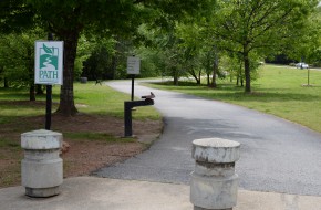
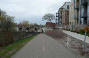
We will design or retrofit trails to provide convenient and barrier-free access to adjacent streets and major destinations. A trail that provides miles but does not connect to its surroundings may provide benefits to people seeking workouts, but it fails in its transportation mission to move people to places. In addition, poor access or visibility to and from surroundings can create public safety problems as well. We must design new trails and retrofit existing trails to provide frequent and comfortable access to wayside destinations and streets, with clear signage that helps orient users to their location.
Click to expand policy information.
Create a standards for trails based on industry standards, “Crime Prevention Through Environmental Design” principles, expected use, and surrounding land uses.
Acquire easements in new and existing developments to develop and connect trails.
Establish connections between parks, residential areas, and other points of interest by constructing additional bike routes, trails and pedestrian paths to meet the growing demands for recreation and alternative transportation routes.
Require that new development tie into the park and trail system by providing linkages to existing parks or dedicating new park land. Connect existing parks and neighborhoods to create a continuous system of open spaces, for example along stream corridors.
We will develop and implement a strategic plan for the city’s pedestrian network, building on the foundation of the 2013 Sidewalk Master Plan for MAPS 3. The 2013 Sidewalk Master Plan was a significant step forward, including an analysis of pedestrian demand in different parts of the city. However, its primary purpose was to identify priority projects for a specific sidewalk construction category of MAPS 3. Many of these projects supply new sidewalks along major corridors with high demand, based on a systematic rating system. These are extremely important, but many other problems remain, including:
- Neighborhood sidewalks on local streets that provide access to destinations such as schools and transit stops.
- Barriers to pedestrian travel such as major intersections, long arterial street crossings, and signal timing.
- Relationship of sidewalks to other parts of the active transportation network, including multi-modal streets, bicycle facilities, transit, connections to adjacent development, and trail access.
These issues require an expanded pedestrian system plan that:
- Identifies a Complete Streets Network prioritizing pedestrian corridors that should be developed and funded as part of the city’s transportation program. The MAPS 3 and previous bond issue study provide a starting point for this network.
- Establishes standards for local sidewalk coverage and a process to evaluate pedestrian service on a neighborhood by neighborhood basis. An example of such a standard would be provision of a complete and well-maintained web of sidewalks within a 1/2 mile walking radius of elementary and middle schools.
- Identifies key pedestrian barriers that obstruct access for important user groups, including children and older adults. This effort should include standards and techniques to minimize these barriers.
- Relates other active modes or facilities to the sidewalk network.
- Provides a phased implementation program that may include individual categories of funding, such as neighborhood target areas and major network investments.
Click to expand policy information.
Enhance the safety and walkability of the sidewalk network through:
- Establishing a citywide bicycle and pedestrian master plan that includes an inventory of sidewalk locations and conditions, and priorities for enhancement.
- Implementing sidewalk improvements through future bond issues, CIP projects or other sources of funding as prioritized in the citywide bicycle and pedestrian master plan.
- Maintaining currency of the citywide bicycle and pedestrian master plan.
- Explore the feasibility of the City assuming responsibility for sidewalk maintenance.
Establish requirements for providing alternate pedestrian routes when construction activity prohibits use of existing facilities.
We will implement sidewalk requirements for both land use typology areas (LUTAs) and street typology standards in city development ordinances and standard practice. Different LUTAs will have different levels of pedestrian activity. Thus, different solutions may be applied to achieve the overall goal of providing appropriate pedestrian service. For example, a loop of local streets in an Urban-Low Intensity LUTA and a street grid in an Urban High-Intensity area will require different approaches to achieve areawide service. Different types of streets also have different sidewalk requirements based on their function and context. City design standards and implementing ordinances should reflect these differences in width, setback, connection, density, and presence of alternatives like trails or other off-street paths.
Click to expand policy information.
Establish regulations that require pedestrian connections between new commercial development and adjoining residential areas.
Prioritize street maintenance projects in the Capital Improvement Plan based on the Public Works Department’s street condition data and traffic volumes.
We will establish clear private and public funding mechanisms for sidewalk construction and repair, and define and enforce maintenance responsibilities for property owners. Several issues complicate funding and maintenance requirements. First, sidewalks are a community responsibility at both citywide and local levels – failure to comply with requirements by one or two property owners can deprive many people of access. Second, in many cases, people with the least ability to build, repair, or maintain sidewalks have the greatest need for them. Third, funding for sidewalks has often been collected through special assessments, often leading to opposition from adjacent property owners. We must develop alternatives that encourage sidewalk connectivity and maintenance. Neighborhoods may be more engaged in sidewalk development or maintenance when owners are unable to meet these responsibilities, and sidewalk networks in local areas may require some level of public funding to be developed fully.
Click to expand policy information.
Enhance the safety and walkability of the sidewalk network through:
- Establishing a citywide bicycle and pedestrian master plan that includes an inventory of sidewalk locations and conditions, and priorities for enhancement.
- Implementing sidewalk improvements through future bond issues, CIP projects or other sources of funding as prioritized in the citywide bicycle and pedestrian master plan.
- Maintaining currency of the citywide bicycle and pedestrian master plan.
- Explore the feasibility of the City assuming responsibility for sidewalk maintenance.
We will begin a cooperative study with the Burlington Northern & Santa Fe (BNSF) Railway and other involved railroads to expand freight and passenger capacity in the north-south corridor. In view of increased freight traffic projections on the BNSF, it will be important to develop a plan to increase capacity in this service corridor. The public has a significant stake in addition to increasing Oklahoma City’s ability to position itself as a freight transportation hub. Increased length and frequency of trains can degrade traffic flow at this line’s relatively frequent grade crossings. Also, from a regional transportation perspective, increased freight traffic on this single line may make commuter rail or additional Amtrak service impossible. A study will examine alternatives that could include an additional track, improved technology, or a freight bypass.
We will work to establish Oklahoma City as a principal intermodal center, beginning with a study to consider the demand, feasibility, and measures necessary to develop such a facility. Oklahoma City, at the intersection of major road, railroad, and air facilities, appears well-positioned to expand its role as a major focus for intermodal freight and distribution. The impact of such a center can be very beneficial in terms of new jobs, investment, and even redevelopment of brownfields industrial sites. One of the newest intermodal facilities, the BNSF’s Kansas City Intermodal Facility and the associated Logistics Park, is opening with about one million square feet of warehousing space and is projected to attract up to 15 million square feet of warehousing, distribution, and associated industry, with employment in excess of 2,000 people. The private and public sectors of our community should examine the feasibility of such a facility, potential sites, potential developers, and steps necessary to execute the concept.
Click to expand policy information.
Identify and prioritize freight infrastructure projects that are needed to maintain mobility and enhance the city’s (and region’s) economic competitiveness.
Initiate a long-range planning process for the expansion of the BNSF freight corridor.
Use established mechanisms/tools to allow property owners to provide for the perpetual maintenance, repair and reconstruction of private roads, sidewalks, trails, utilities, and parks in new housing developments by requiring funding mechanisms such as:
- Maintenance bonds/escrows
- Special assessment districts, such as Business Improvement District or Special Improvement District
- Covenants requiring compulsory membership in an incorporated Property Owners Association whose members will be financially liable for any such maintenance, repair, or reconstruction costs.
Incorporate these financing options into the platting process (or zoning process in the case of PUDs).
Construct all private roads and utilities to comply with minimum design and paving standards as outlined in the City of Oklahoma City Subdivision Regulations, including those related to the appropriate Street Typology.
We will ensure that our streets balance the needs of all users and modes. This requires a consistent and thoughtful approach to making investments in our multi-modal transportation system incrementally over time. It is our goal to ensure that streets are planned, designed, operated, and maintained to enable safe, convenient, and comfortable travel, and access for users of all ages and abilities. For this to become a reality, decisions that affect how investments are made and streets are designed should consult the “Livable Streets” principles and ideal standards for street typologies in planokc. Multiple City departments and decision-making bodies help implement this goal, including Public Works, Planning, Development Services, COTPA, MAPS, Utilities, Parks and Recreation, as well as the design review committees and commissions, Traffic and Transportation Commission, Planning Commission, and City Council.
Click to expand policy information.
Coordinate the design, development, expansion, and/or investment in transportation projects with the Land Use Typology map.
Require the construction of new streets, streetscapes, and street widening projects to implement the design components of the assigned street typologies established in this plan.
Revise Subdivision Regulations and development standards to reflect the street typology standards.
When approving projects that improve the level of service for vehicular traffic, ensure they do not negatively impact the walkability or bikeability of the area.
Require sidewalks on both sides of all streets in urban LUTAs and in the Rural Residential LUTA for subdivisions with densities greater than 1 unit per acre.
Prioritize construction of pedestrian and bicycle facilities that improve connectivity and eliminate gaps in the transportation network.
Set level of service goals and adopt standards to improve the performance of pedestrian, bicycle, and transit facilities. Emphasize pedestrian, bicycle and transit infrastructure in street widening designs.
Increase the miles of bike lanes by:
- Including bicycle lanes in future road widening, reconstruction, and resurfacing projects; and
- Adding bicycle lanes to streets that have sufficient capacity.
Create and implement a citywide bicycle and pedestrian master plan that addresses riders of all levels.
Enhance the safety and walkability of the sidewalk network through:
- Establishing a citywide bicycle and pedestrian master plan that includes an inventory of sidewalk locations and conditions, and priorities for enhancement.
- Implementing sidewalk improvements through future bond issues, CIP projects or other sources of funding as prioritized in the citywide bicycle and pedestrian master plan.
- Maintaining currency of the citywide bicycle and pedestrian master plan.
- Explore the feasibility of the City assuming responsibility for sidewalk maintenance.
Establish access management requirements that limit driveways on arterials and collectors and increase connections between uses to improve safety and traffic efficiency.
Limit driveways on arterials and collectors and increase connections between uses to improve safety and traffic efficiency.
Revise development standards to require sidewalks and transit stops along existing and planned transit routes.
Develop design standards for bus stops and transit stations that consider location, make connections to sidewalks and bicycle routes/trails, and provide safe, comfortable, and attractive waiting areas for riders.
Adopt subdivision regulations that ensure new neighborhoods meet the basic needs of residents while supporting an efficient development pattern. Regulations should cover:
- Open space (passive and active),
- Demonstration of sustainable funding levels for common area and facility maintenance costs,
- Walkability and bikeability,
- Internal and external street connectivity,
- Block length,
- Integration of uses,
- Integration of a variety of home sizes,
- Integration of a variety of unit types, and
- Preservation of Environmentally Sensitive Areas.
Regulations could be based on a point scale to allow flexibility, while still requiring basic minimum thresholds be met.
New regulations should remove the existing requirement for development in Rural LUTAs to connect to water and sewer systems and establish a minimum one-acre lot size for lots with on-site sewer treatment.
Identify priority areas where the City can maximize private investment by providing public infrastructure and amenities including:
- Transit;
- Parks, trails, sidewalks;
- Streets;
- Arts and cultural facilities.
Catalyze infill development on vacant, underutilized, and brownfield sites in urbanized areas by:
- Investing in infrastructure improvements;
- Improving multi-modal transportation networks;
- Improving parks and open spaces;
- Improving schools and other civic resources;
- Exploring innovative methods such as:
- A public-private partnership to purchase problem properties in target areas and build or rehabilitate homes while improving infrastructure and amenities
- An infill house plan program similar to Sacramento or Milwaukee
- Identifying and removing barriers to rehabilitation and/or replacement of residential buildings.
- Establishing a position in the City to facilitate medium- and large-scale redevelopment projects through the development process by guiding interactions with City departments, allied agencies, and utility companies.
Regional-, community-, and neighborhood-scale retail developments should provide an internal vehicle and pedestrian circulation system between new and existing centers and individual stores that draws on the following principles:
- Concentrate access for new retail development at shared primary entrance points. Primary entrance points should be aligned with access points immediately across intersecting roads. Limit curb cuts on primary highways and arterials.
- Provide pedestrian circulation, including sidewalks and median breaks along interior and exterior fronting roads and within parking lots.
- Encourage coordinated development of retail centers in order to facilitate internal pedestrian and vehicle circulation and optimal center performance.
Improve parking provisions in neighborhoods that are near vibrant commercial corridors/areas by improving parking and corridor design, non-vehicular networks, transit, and signage.
Establish development regulations that help improve air quality, including:
- Specifying construction controls that reduce airborne dust;
- Increasing landscaping and tree planting to absorb carbon dioxide and air pollutants; and
- Encouraging development patterns and densities that support alternative modes of transportation in the urban LUTAs.
Promote improved air quality and reduced ground-level ozone levels by developing a public education program that will inform residents about the air quality benefits of:
- Proper automobile maintenance
- Proper maintenance and use of gas-powered lawn and garden equipment
- Limiting car idling times
- Alternative fuels
- Alternative / active transportation modes (public transit, walking, biking, car-sharing, etc.)
- Reducing vehicle-miles traveled (VMT)
- Employer sponsored emission reduction programs (carpooling, work from home, telecommuting, etc.)
- Native landscaping (requiring less maintenance)
- Energy efficient housing / buildings





 Download PDF